This has proven to be an active winter, which has just added an extra headache into planning sections. I think at this point it is safe to say I would recommend a thru-hike any day over section hiking. That said, sometimes life calls for section hiking and if that is the best way to go well, it's better than nothing. This weekend as I headed into the foothills of NC the family came along. This certainly made the logistics of the weekend easier. We got ourselves an Airbnb just outside of Elkin, NC which has worked hard to become the trail town of the MST. It was a cold weekend and we had some accumulation of snow on Saturday night ending as freezing rain and then rain on Sunday morning. Those that hike a lot have heard the saying the most dangerous part of the trip is getting to the trailhead. Due to the conditions, I didn't really believe it to be worth the risk to try and hike as planned on Sunday. As I write it looks like my next planned weekend out might just be filled with much more snow, we'll play things by ear.
I introduced the bike this weekend so I'll separate out the miles between hiking and biking.
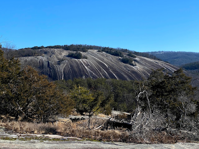 |
| Stone Mountain from Cedar Rock |
Day 22 January 29
Miles: 18.5
Weather: Cold! starting temps in the low 20's, High's in the low 40's with some wind in the afternoon
Camping: No camping this weekend, Airbnb outside Elkin, NC
Before I start into the journal I'll mention for camping on this section I would have chosen to do a longer day and make it over to Byrds Branch Campground, which is open year round. It's located right on the trail next to the Carter Falls trailhead.
I left the house after eating a few homemade cinnamon rolls just after 7am. When I reached the backpackers lot at Stone Mountain around 9am the car thermometer still read 24 degrees outside! I quickly gathered my things and took off on the trail at a run for just a short time to get the blood flowing. The rhododendrons were curled shut and the ground crunched below my feet. Luckily the trail moved out of the cold valley and onto a south facing hillside. I was comfortable at this point and the rhododendrons in the sun had started to fan out a little. My first point of interest today was Wolf Rock. There were some icy sections of trail as I came to this viewpoint but it was all patchy so it wasn't difficult to find solid ground with traction. The views back to the parkway were great and I also got to enjoy this with no crowds. From Wolf rock the trail takes you to Cedar Rock. It's at Cedar Rock that you get the first glimpse up close of Stone Mountain itself. As I left this rock heading for the base of Stone Mountain I could hear some folks coming up the trail behind me but would go without seeing anyone really until later in the day. I quickly checked out the homestead at the base of Stone Mountain before continuing. The life would have been hard but waking up and walking out of your house everyday to that view would have been pretty awesome.
 |
| Trail goes to the left, not across! |
The trail crossed some creeks a few times on bridges, before coming to a larger creek with no bridge. I didn't really plan for a cold creek crossing mentally, so I was not happy. As I was trying to find a shallow quick way across I noticed a small sign pointing that the MST was going to turn left. Basically, in the summer you would simply walk downstream in the creek and then turn left. There was a small stream that emptied into the larger creek which I needed to cross to reach this trail. This proved much easier and I managed to keep dry which made me happy. It was pretty much all horse trail from here to the exit of the Park. From there some road walking for a short time before heading into the woods again.
 |
| Old silo "1941" along one of the Gravel Roads |
On a warmer day of the year a detour and stop at the Stone Mountain Country Store would probably have been in the works but I just wanted to keep moving and not worry about getting cold while stopping. Soon the trail ended and it was onto the roads. There was more paved roads than gravel and the walking was pretty easy. The views are also pretty nice in this area. The topography is mostly the same except for one hill sticking up. I would venture to say anyone who had no clue of the area would have guessed correctly that the trail would go to the top. The hill was Wells Knob, I was happy to get back on a natural surface and off the road for this uphill climb. I made arrangements with my wife to get picked up at a road intersection just on the other side of the knob. Timing worked out well and my family who had left a little later in the morning and had been exploring Stone Mountain themselves came to pick me up. We headed back to the park to pick up my car before making our way to the farm house we were staying at for the weekend.
 |
| Wells Knob in the distance |
Day 23 January 30
Miles: 39.2 miles of biking includes a 0.5 mi detour due to bridge work on Hardy road, 7.2 miles of hiking includes 1 mile Carter Falls loop which is blazed with MST trail markers but not yet in the guidebook as the official path. Total for the day: 46.4 miles
Weather: Low 20's starting out and 40's in the afternoon. Clouds moving in throughout the day.
Camping: Airbnb outside Elkin
For camping in this section I'm not sure what I would have done. There is a river outfitter in Rockford that offers camping, although I did not verify to see if they still did this or do this during the winter months. After Rockford the next camping area seems to be Pilot Mountain State Park. Somehow Stone Mtn. and Hanging Rock State Parks can keep their campgrounds open in the winter but Pilot Mountain closes down until March 15th. To be fair, many of the issues I'm having would not exist if I just hiked in the "regular" hiking season but winter in NC is still a great time to get out backpacking.
I got dropped off with my bike along the road just at the base of Wells Knob around 9 am I believe. I had 5.7 miles to Carter Falls trailhead all of which was road walking so I opted just to go ahead and start the biking. One of the roads was gravel but it was well traveled so the bike did fine on that. My tires are larger than regular road bike tires but not the best for off road travel. This was a good warm up and a nice section to ride. What would have taken around and hour and a half to two hours to hike I completed in just over 30 mins. My wife and kids had parked and hiked down to Carter Falls, I attached my bike back to our van and headed down to check out the falls. There are two trails out of this parking area and they do make a loop, so check out the whole thing (maps can be found on Elkin Valley Trails Association website).
 |
| Along the Elkin Alleghany Rail Trail |
From Carter Falls it's mostly trail into Elkin. I said goodbye and took off on trail through Byrds Branch Campground. We met a local hiker out by the falls and I caught up with him just past the campground. We hiked together until Issac's Trailhead where the MST goes along road again for a few miles. He volunteers with the Elkin Valley Trails Association (EVTA) and had lots of great information on the trails they had built and some of the plans that had in the future. I'm very thankful for all those that get out and do that work! Once into Elkin the trial follows alongside a major road with lots of businesses. If you are thru-hiking you will certainly plan to resupply here. The trail then takes you up into a neighborhood where a gravel road eventually runs you into the Elkin Alleghany Rail Trail. There was a big gong so I gave that a ring and up the hill came some familiar and loud bikers, followed not long after their mom and a sleeping baby. We strolled back to the Elkin Recreation area park at the edge of downtown and I loaded up for my second bike section.
We bought bike panniers when living in Portland, OR years ago, unfortunately one of them was destroyed by a mouse in our garage. The good thing is that pretty much all of my gear fits into one pannier. I'm able to strap my backpack on the back of my bike and carry one pannier which gives me more than enough room for everything I need on a bike trip. That also makes it easy to transition from biking to backpacking. By 1:00 I was on the road and now bike touring! This was the longest ride I've done in years and I've never ridden with my gear before so this is all just an experiment. The roads were up and down but generally low traffic and those out on the road gave me plenty of room. Safe to say this is the most dangerous part of the trip I've encountered yet. That's funny because most people would be afraid and worried about the woods, I'm personally more concerned about people.
 |
| Bike setup: one pannier and my backpack |
Early in the ride as I rounded a curve I watched as a hawk quickly flew out of a tree. As it took off I could see it had something in its' talons. Sure enough it had a full size squirrel and it dropped that squirrel right on the road in front of me. The squirrel saw me coming and gingerly hopped off the road before any cars came. I'm not sure if the Hawk made it back to find the squirrel or not but for now I would say that was a pretty lucky squirrel. I had a few dogs that barked and chased me a bit which I never really like and need to come up with a plan to deal with them but my biggest encounter of the day was a dog owner. I don't even remember exactly where I was along the trail but I had been riding for a while and was heading slightly uphill or just taking a little break and going slowly. I saw a dog get up and start barking so naturally I took a look to see if it was charging. It seemed to be leashed, I was riding on the right and this dog is in a yard on the left so I just kept at my pace. I also generally look around for cars when I encounter dogs so I know what's around if I need to move to one side of the road or another and secondly so I can signal to them about a dog that might shoot out in front of them.
In this case looking around was a pure sin, some crazy homeowner just starts berating me, using every term you could think to yell at someone telling me to keep pedaling and keep my eyes on the road. He was genuinely pissed off I was riding my bike on a State maintained road and a State trail in front of his house. It took everything I could not to stop and give him a piece of my mind but I understood where I was riding, he is at home with a car and likely guns and I'm just on a bike so best to keep going and not make him more upset. For those planning to ride this section though just beware there is a homeowner who is not a fan of this trail bringing bikers near his house.
The rest of my ride was pretty good. With about 12 miles left I just started to get tired. I stopped in an area with some fields and away from houses to eat a bunch of snacks. Looking at the profile I knew I had at least two more substantial hills to climb. One of those hills I just gave up on, it seemed I had reached the point where I could just get off and walk faster than riding. Not much longer I came to one last hill, it was not as steep so I mentally was able to power through. My family was waiting down at the parking area by the corridor trail most of them asleep from their day of adventures.
I certainly prefer the biking over road walking but there are new logistics and mental challenges that you face when on a bike that I don't have to consider when walking. I'm sure it will take a few times out to figure out my system but overall I'm pleased with the transition. From this point I'll hike again until I reach Hanging Rock State Park. After that it alternates from biking to hiking several times.
Total Weekend Miles: 64.9
Total MST Miles: 418.2


Comments
Post a Comment