MST: Clingmans Dome to Balsam Gap
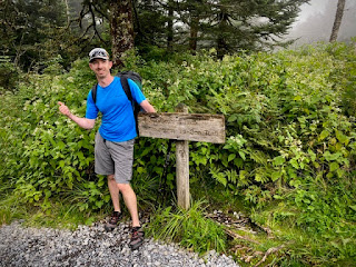
In 2007 while hiking the AT I came to the summit of Clingmans Dome in the clouds, winds whipping, ground covered in snow and not a sign of people. That was in December and the road was closed. It’s a little different today, although there were good views in the parking lot below, the top was in the clouds, crowded with people (don the mask) and not as windy. It’s time to Start!
The Plan
In my last post I mentioned my concern over the high miles to start my trip. After much deliberation I found a plan I felt would work well. My wife and kids (-1) were driving me up to the start. We would camp at Smokemont campground Friday night and wake up early so I could get a start on a 20.8 mile day Saturday. Instead of that, I now would walk the first 3.9 miles of trail plus 0.6 mile up to Clingmans on Friday evening, camp with them and get dropped off at the Fork Ridge trailhead the next morning for a 16.3 mi day. My overall distance for the weekend is no different but if you have thru-hiked or done any long hike you know sometimes it's the mental game you are playing against not a physical game. My mind is at ease with a 16.3 mile but not a 20.8 mile both followed by a 19 mile day.
The Journey Begins
Day 1
Miles: 3.9 MST/ 4.5 total
Weather: Upper 50’s low 60’s and cloudy.
Camping: Smokemont Campground, Great Smoky Mountains National Park (GSMNP)
The best part of our new plan was now my wife and kids could all hike up with me to the top. We made our way up, took some photos and I set off around 5:45 pm. I had a great evening stroll and moved quicker than I expected (full pack in tow for any of those wondering). My wife and kids walked back down to have a picnic at the parking lot and would meet me at the Fork Ridge Trail, I estimated around 2 hours.
The trail follows the AT through here and other than being a creek for much of the way, was in good shape. I think they had a substantial rain prior to our arrival. The trail follows the ridge line so there are some ups and down but nothing major. By 7:00 pm I was back to the summit road where I waited just a minute or so before my ride arrived. The boys expected they would get to hike in to meet me so to avoid any sadness we took some extra time to walk a little ways down the Fork Ridge trail before heading down to camp.
Day 2
Miles 16.3
Weather: Sunny 70's Great! Mid 40's at the Clingmans parking area at sunrise.
Camping: Backcountry Site #52 Newton Bald, GSMNP
We woke the boys up early this morning to drive up to the trailhead, a change of rolls :). We did detour up to the summit parking area which had a great sunrise but was chilly! Once at the trailhead I got my pack out sat down in the van and ate a krispy kreme doughnut and said my goodbyes. I was on trail around 7:20 am and really enjoyed the day of hiking. The MST starts by taking you down 5.1 miles to the Deep Creek trail. There were massive trees all through the Smokies but I remember thinking how terrible it would be to hike on any of these trails soon after a large storm. The blow downs that were cut and cleared out of the way were just giants. I would hate having to navigate around, over or through them. The crossing of Deep creek was pretty easy, I stopped and quickly changed into my Z-trails, which I then wore for the next 3.5 miles. The route I took through the creek was very easy and safe but was knee deep for just a couple of steps it seemed.


After the initial crossing you follow along Deep Creek. The guide mentions several more substantial crossings in the next 3.5 miles, those crossings are not of Deep Creek but other streams flowing into Deep Creek. None of them were very deep but most likely you would get water in your shoes, so wearing the sandals worked out. There was one blow down to navigate through in this section but after another mile or so it looks like trail crews had recently come through and really cleared the path which was great. Once you reach Martins Gap trail you start going up but it's pretty reasonable and gradual in my opinion. I managed to startle a large animal likely a bear by the sound it made but I did not take the time to pause as it took off down one side of the ridge, I continued along in the opposite direction. Normally I would make noise while hiking but I was looking at my mileage guide to decide on stopping for lunch, now the decision was made for me to just keep hiking a little.
I made it into the Newton Bald Campsite at 3 pm. The water source is down a steep hill with a blowdown to crawl over but it is a frigid spring that is great for drinking! There was one small group of people at camp and the site was full for the night. A couple other guys that were section hiking the MST came in a few hours after my arrival. They started at Clingmans that morning and did the big 20 mile day. I just enjoyed the afternoon and kicked my feet up to rest for the big day tomorrow.
Day 3
Miles: 19.0
Weather: Sunny highs in the 70's
Camping: Mile High Campground, Cherokee Indian Reservation
This day is much like yesterday in terms of the profile. It starts with a long descent and ends with a long ascent. I took off from Newton Bald later than I was hoping but was still on trail shortly after 7 am. There was no need for a headlamp as the sun was up just enough to light the way. The greatest part of this day was certainly the morning hiking along the ridge. I really enjoy hiking ridges as you can move quickly and although not clear openings in the morning you can make out the scenery beyond the trees. After some ridge walking it was down hill to Mingus Mill. Nothing spectacular stands out on this section. Just some good quality hiking. In the guide it said "Ford wide but shallow Mudcap Branch", which I expected I might need to change shoes for but this was really a quick rock hop without much thought. I think the word "ford" may make it seem a little more tricky, like one of those Oregon Trail crossings.
The road walking started just before Mingus Mill on a gravel road and would be the story for the rest of the day. I suspected that I would really not like road walking, partly the reason I will bike through the central part of the State where trails do not exist. I was unsure how it would affect me mentally as the only thing I can think to compare it to on the AT was walking into a town if you didn't get a ride or the C&O Canal outside of Harpers Ferry. After the Mill you head to the GSMNP visitor center take a short trail to the Blue Ridge Parkway (BRP) and walk along the shoulder of the road. The parkway was quiet (until after lunch) and shaded in this area which made it nice. There were also nicely spaced overlooks that broke the walking up along with some trail around tunnels which are illegal to walk through. So, although concerned that mundane road walking would wear me down, mentally I was fine and moved at a really good pace. Once again I made it to camp by 3 pm. I would just hang out and rest again before taking in the sunset at the viewing platform at Mile High Campground.

Miles: 17.2 MST / 17.8 Total
Weather: Sunny highs 70's
Camping: Home (Car parked at BRP Maintenance area at Balsam Gap Mile 9.6 of Segment 2)
Today started as planned, I was out on the trail shortly after 6 am. It was downhill walking on a gravel road to Soco Gap where I stopped for some breakfast. The next section is all trail with some fresh trail work. A big thanks to those trail workers who come out and keep these trails in great condition. I love uphill, it just makes me want to keep pushing. I also love the Spruce-Fir forest, which is where I found myself as I approached Waterrock Knob. Of the whole weekend this section (Soco to Waterrock) was my favorite. It was a crystal clear day at Waterrock Knob. I could see where I started and also where I’m heading over the next month or so which is really cool.
After Waterrock the trail heads down to Balsam Gap. This is a true Southern Appalachian downhill which means you go on a rollercoaster of ups and downs many of which are steep for short periods. Eventually, the trail ends and you find yourself on the worst road yet. A gravel road with fresh gravel and no real compacted dirt to walk on for more comfort. The road also is the end of the rollercoaster and goes downhill at a steady rate. At the end it dumps you right out at the parkway which was really busy today. I walked with traffic as there was more room along that side of the road. After one small section of trail I had reached my car. I’m certainly wishing I could just keep going but also leaving very pleased with the start that I’ve made. The weather was a very good friend this trip and I'm very aware of that.

Notes: For those wishing to thru hike I would have used this same plan. Substitute the Mt. Collins Shelter in for the first nights camping. I would have mailed a resupply box to Balsam picked that up and stayed in the campground listed (not sure what that is like) or maybe a trail angel would step up. The Our State podcast had good stories on Balsam. Speaking of which, season 4 of Away Message is all about the MST so check it out here or download from wherever you get your podcasts.
I’ll be out again towards the end of September. You can subscribe to this and it will email you when I post. Enjoy and if you have questions on these segments let me know, I'm happy to share my knowledge.


Comments
Post a Comment