MST: Balsam Gap to Pisgah Inn
After some family weekends it was time to head out to the trail again. Although I wasn't on the MST I did get to do some great day hiking up in the Dolly Sods, Seneca Rocks area of WV in my time away. None of that counts towards this 1,000 plus mile trip though. I was happy to pick back up where I left off this weekend. Enjoy!
Day 5 September 25
Miles: 22.1Weather: Rain early, heavy at times, foggy, heavy rain again overnight. 50-60's
Camping: Piney Mountain Creek
My wife and youngest son, who clearly showed last night he doesn't mind being up at odd hours of the night or early morning made the trip to drop me off at Balsam Gap. When we arrived to the trailhead I took some time to sort my pack and gear up for the cool rain that was falling. I set off at 6:45 by headlamp and took one last look at the radar thinking, maybe this is as bad as it will get. Within 20 minutes the heavier rain started falling. It was uphill for the first 5 miles so I got to test a system I haven't employed prior. Being too hot from the physical activity, I used my umbrella with no rain jacket and then had a < $30 rain skirt to protect my legs. My legs still got wet but it was a damp feeling not a cold soaking. In the past I would just deal with my legs getting soaked but I think this was an improvement over that or rain pants.
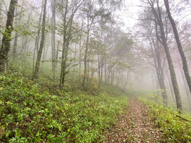
The rest of the day looked like the picture above. It's the kind of day where you just focus on the task at hand, one foot in front of the other. That task is not always so easy with wet rocks, roots and ground that sinks when you step. I took my first fall on the MST, when my hand hit the ground it was as if I fell into fresh powder on a snow day. I'll admit, that result was much more pleasant than if I had hit a rock, but also shows how wet and soft the forest floor was. Not surprising, I saw no one out on the trail today. It ended up being a long day for me and my body was ready to stop when I made it to the campsite around 4pm (Segment 2, mile marker 31.7, description is correct, not much flat ground).
- A note for future hikers about 0.3 miles prior to this there is a campsite on the right hand side as you walk EB. That site looked like it had some better flat spots and was close to the creek. Also note if you stay at the campsite I did, collect water at the creek before or there was a stream running (maybe seasonal, everything is running this year) just past the intersection for the campsite which is closer than back tracking.
Day 6 September 26
Miles: 14.7
Weather: Cloudy with some clearing then cloudy again. Windy overnight lows in 50's highs upper 60's
Camping: Art Loeb Trail near Balsam Knob Road (FR 816)
I guess when I took the fall yesterday I did hit my hip on something as it was bothering me last night when sleeping on my side, but nothing to really worry about. It rained hard last night and I wasn't sure that it would stop in the morning. Due to legal camping areas I knew today would be shorter. In 2015 the USFS decided to close camping in the Graveyard Fields area due to bear activity, overuse was likely a secondary reason.
 The trail today varied from old road beds that were mostly like walking through a creek, to narrow technical sections in spruce-fir forests and tunnels of laurels and rhododendrons leading to rocky outcrops. The guidebook mentions that a couple of miles here are some of the hardest on the trail. There was even a sign for people heading WB about "hazardous trail conditions." The trail in this hazardous section was very narrow, roots and rocks made it technically more challenging but with a little focus it doesn't take long to navigate safely. There are some larger rocks you might think are stable but when you step on them they will wobble.
 I entered the Middle Prong Wilderness which was a great break from the old forest roads earlier in the day. The cascades along Buckeye Creek were pretty cool so I took a longer break to explore downstream. Shortly after leaving the creek the trail goes up to a heath bald. I remember the guide saying the trail follows the edge of a heath bald but found myself going straight up so I confirmed on the hiking project app on my phone that I indeed was off trail. Not sure where I would have ended up but I was getting soaked as this moved through high vegetation. Later in the day I had a good view of a distant waterfall and then some great views from a rock outcrop just before intersecting with the Art Loeb Trail. Just before reaching my camp I stopped to the side to let a small group pass, when I hear my name I look further back in the pack to see two friends. It's great to see familiar faces out in the woods. I made it to my camp around 4pm and unfortunately it is a pretty crowded area but I find a nice spot that will serve me well.
Day 7 September 27
Miles: 17.2
Weather: Mostly Sunny
Camping: Home. End of Segment 2 Pisgah Inn.
It was very windy last night. I woke up multiple times but the last time I looked was 4:55. My alarm was set to go off within an hour but I decided to sleep the extra 45 mins. With the wind and hat on my head I slept right through that alarm. Luckily I did wake up at 6:25 and instead of packing and having breakfast at camp I just packed and started moving. I hit the trail at 7:00 am, there were a couple tents with lights on inside but most were still sleeping. The trail headed uphill and as it went opened up to some views and I was rewarded with a spectacular sunrise.
I stopped to watch the show, had some breakfast and took off some warm layers before continuing. The views stuck around for just a little while before I entered what I call the hiker wash. Much like the heath bald photo from day 6 above, the vegetation was tall and closed in on the trail. This vegetation combined with rain and/or dew results in a soaking from head to toe. If I had started hiking when I planned I would have had no sunrise views so as usual things seem to work the way they should.
Being so early I also passed through the Skinny Dip Falls area around 9:30. There was only one other person at the falls, a couple others would arrive while I was there. Likely within an hour it will be overrun with people. I spent time downstream from the falls and filled up on some water before taking off. This next section of trail parallels the BRP along a ridge that had a great outcrop to view Looking Glass. I really loved the uphill and for those going WB you'll really hate walking up the other side. I made it to the Parkway crossing prior to NC 276 by lunch. I found a dry rock which was a luxury I had not experienced this weekend so I sat down to eat.
 |
| Below Skinny Dip Falls |
 |
| Looking Glass Rock |
After lunch I had 7 miles left and this section goes below the parkway through diverse cove forests. There were numerous crossings of small streams around every corner. Many of these during this time of year are likely non-existent or running low. This year they have had plenty of water so they were actually all flowing very well. I even ended up getting a foot wet on one crossing, which is unusual for such small drainages. When I reach the top of the final switchback before Pisgah Inn I saw four familiar faces just stopping up ahead. My wife and kids had hiked down to meet me but were turned around due to one of those drainages (I wouldn't have wanted to manage getting two kids across while carrying a third in a pack either). We headed up to the Inn and that was the end of my weekend and segment 2 for the MST. Looking ahead segment 3 is 71.4 miles long from Pisgah Inn to Black Mountain Campground.
- If thru-hiking I would likely stay at the campground here and enjoy dinner at the Inn. They have sandwiches and a small selection of snacks that could be a small boost to your food supplies until you get into Asheville for a major resupply. I made it to Pisgah Inn by 3pm.
Total weekend miles: 54.0
Total miles of MST completed: 110.4
The Friends of The Mountains to Sea Trail have an interactive google map on their website if you wish to check out the locations I'm talking about. Check it out!


Comments
Post a Comment